Footpath Route Planner

Footpath Route Planner

By Half Mile Labs LLC

  • Category: Navigation
  • Release Date: 2013-05-07
  • Current Version: 4.9.15
  • Adult Rating: 4+
  • File Size: 131.13 MB
  • Developer: Half Mile Labs LLC
  • Compatibility: Requires iOS 15.0 or later.
Score: 4.7
4.78958
From 17,308 Ratings

Description

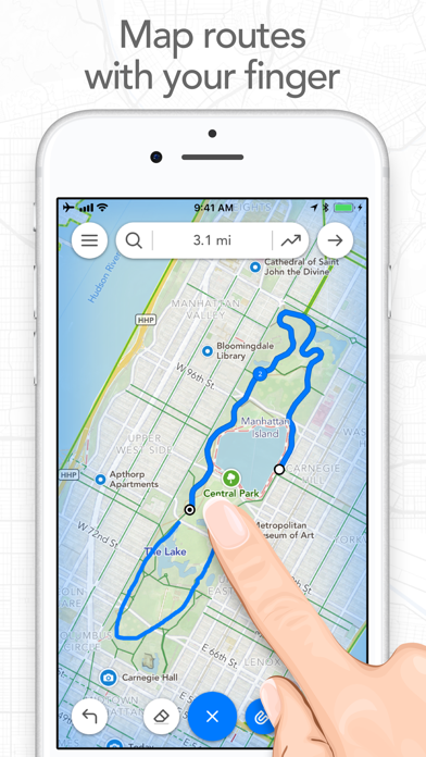
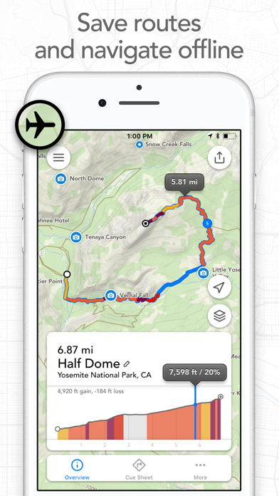
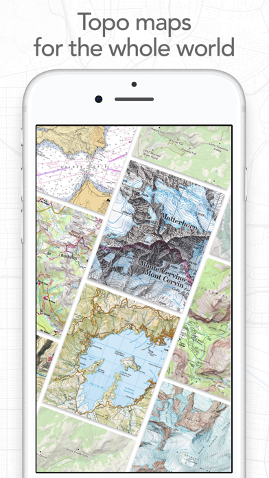
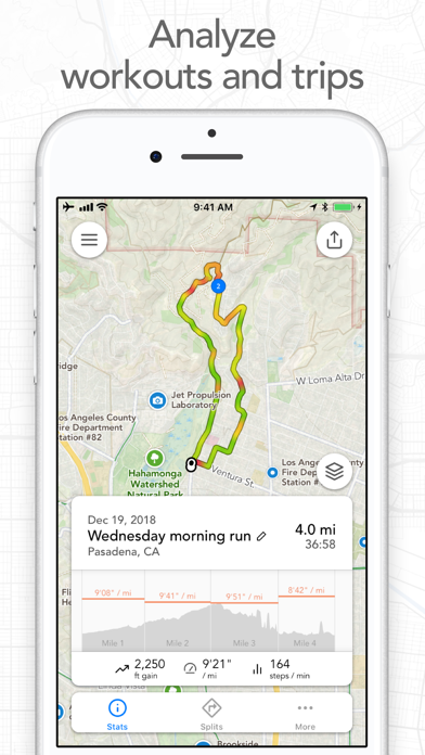
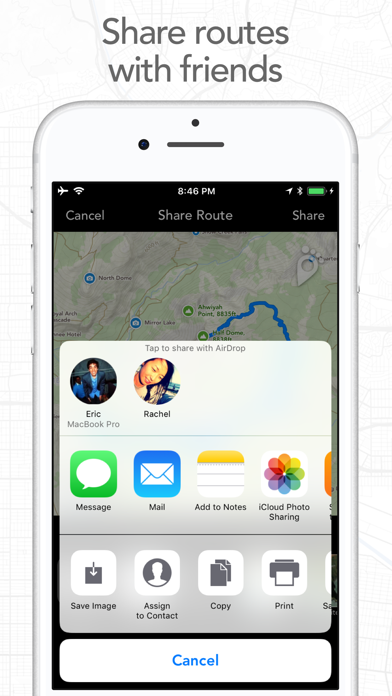
Map routes with your finger and Footpath will snap to roads and trails. Measure distances and elevations in seconds, then navigate along with turn-by-turn directions. Footpath is the ultimate companion for planning and navigating custom routes. Join millions of adventurers and plan out your perfect route. SNAP TO MAP Quickly measure distances by tracing a map with your finger or Apple Pencil. Footpath will snap to roads and trails on the map. MEASURE DISTANCE AND ELEVATION Know exactly how far and how high you'll travel with elevation profiles. Plan routes that match your goals. SAVE ROUTES FOR LATER Plan out your week or trip. Keep up to 5 routes on hand for reference, or save unlimited routes with Footpath Elite. SHARE ROUTES Send your routes to friends or workout partners to open on their device. Footpath is designed to work for pretty much any activity or adventure, in any country: • Running • Cycling and mountain biking • Hiking and mountaineering • Walking • Motorcycling and driving • Backcountry skiing • Kayaking and standup paddleboarding • Sailing • And many more! FOOTPATH ELITE Ready to go the extra mile? Upgrading to Footpath Elite unlocks the following powerful features: TURN-BY-TURN NAVIGATION - Footpath will tell you when to turn with turn-by-turn audio cues on your iPhone and Apple Watch - Save your route and cues in advance for voice guidance that works completely offline - Double tap your AirPods or use the playback controls button on your headphones to replay your next cue PREMIUM OFFLINE MAPS - 3D and topographic maps including Footpath Outdoors (Worldwide), USGS Topo Maps (U.S. and Canada), OpenCycleMap (Worldwide), and many more - Cycling lanes, avalanche slope shading, and elevation contour lines - Download maps for use offline - Save places as favorites to customize your maps ORGANIZE - Create and edit unlimited saved routes - Duplicate, merge, and split routes - Organize and sort routes into custom lists ANALYZE - Record GPS tracks of your activities - Use HealthKit display and log extra health and fitness metrics such as heart rate during a GPS activity - View a calendar log and weekly summary of your activities - Analyze splits, speed, elevation, and heart rate - View a heatmap of your speed during your activity EXPORT - GPX import and export - TCX and FIT course export for turn-by-turn navigation on Garmin and Wahoo GPS devices - Export cue sheets to a spreadsheet app for customization and printing - Export your routes and workouts to Apple Health You can purchase a Footpath Elite monthly or yearly subscription through your iTunes account. Your subscription will automatically renew unless cancelled at least 24 hours before the end of the current period. Auto-renew can be turned off anytime by going to the Manage Subscriptions page in settings after purchase, and your features will remain active until the end of the subscription period. Your account will be charged for renewal within 24-hours prior to the end of the current period at the same cost as your original purchase. TIPS FOR MAPPING ROUTES • For longer routes, try zooming in and mapping your route in multiple segments. • Tap and hold the map to quickly route between waypoints and POIs. • Did Footpath snap to the wrong roads? Trace over the incorrect segment to edit, or use the eraser tool. • Turn off snap to roads (magnet icon) and zoom in to manually trace the map. (Try switching to a satellite layer). • Displaying maps and continuously running GPS in the background can dramatically decrease battery life. Navigate without maps or with the screen off for all day battery life. CONTACT US We've got a lot planned for Footpath. If you have any suggestions or feedback, or if you run into any issues, please contact us at support@footpathapp.com Terms of Service: https://footpathapp.com/terms Privacy Policy: https://footpathapp.com/privacy

Screenshots

Reviews

  • Watch navigation stopped working

    1
    By Timbers fan 16385
    I purchased a subscription to this app because it was formerly considered the best hiking navigation for the Apple Watch Ultra. I imported GPX tracks from AllTrails, then used Footpath from my watch on the trail. Now hikes will no longer launch on my watch from Footpath, although I’m doing the same thing. I waited a month to see if they would fix it but they haven’t, so I cancelled my subscription, got one for AllTrails, and will be using their functional watch app for hiking navigation. It’s not as good as Footpath used to be on the watch, but it’s better than what it now offers - nothing.
  • Best app for building routes

    5
    By Duffman11s
    Everything else that comes close in usability is behind a paywall
  • Loving this app!!!

    4
    By Wanted2ReviewButNoNamesLeft
    The only reason I didn’t give a 5 star, could be my own fault. Ending a run on my Apple Watch is always confusing. I’m never sure how to end it, and once I do, I’m not sure how I got there. Having said that, I love this app. I love creating my routes, I love the colors that show me the hard hills, I love being able to transfer my route to my watch, I love that most of the time the turn-by-turn instructions come through my Shokz (occasionally if my STRAVA- which never comes through my Shokz- announces my mileage in close time to a turn, footpath will announce through my watch, but then reset and come back through my Shokz). I’ll be going on vacation and I’m using footpath to plan my runs in another state. Soooo worth it! Thank you!
  • Plan Perfect

    5
    By Tamizhachi
    Nice app to plan running or biking routes ahead of time. Provides elevation stats to plan perfectly.
  • App is inconsistent

    4
    By Tee Tee85
    App isn’t consistent writing to Apple health. I like logging outdoor runs and walks with the app and love the outline of the route that shows on my watch at the end of a workout but I’m always afraid that my workout won’t save in health. I shouldn’t have to buy elite to export it later.
  • Great at what it does

    4
    By NickBel0326
    This app is very good at what it is intended to do (or at least what I intend to use it for). I just wish it had better integration with third party apps such as Strava. I mapped out a backcountry XC ski route in an area without signal and service with the intention of using offline maps and cue. It was very easy and intuitive to draw the route in my iPhone. transferring to my Apple Watch Ultra 2 for the offline map and cues was a breeze. It worked very accurately starting in an area miles away from cell service. I was able to run Strava in the background with a couple of swiping press of the buttons. This third party app takes advantage of what Apple has set up for developers to use to make the Ultra 2 compete with Garmin Epic and Fénix.
  • Really hard to edit

    1
    By drvstrnz
    Extremely hard to edit a track, it would be nice to edit this on a windows desktop, I’m working on an iPad and it really makes life difficult.
  • Looks promising 😇

    4
    By dougXN
    So I haven’t used it a ton yet, but it looks promising and here’s why: 1- use what ever mode you want - boat, walking bike and car- perhaps more🙃 2- it finds a route by drawing it or selecting a end point - and/or a start point! What I haven’t quite used or figured out: - navigation part - the “go” button - how well the path for hiking works - if it is the best route for driving/walking/biking. By best I mean the one that would make sense and be best for what ever mode you choose. Anyway, it will be interesting to test it out. Finally, I would add, If it does most of what it offers, then the price point makes it a good value!
  • Temperamental

    1
    By Disasterjunkie
    Your satélite maps needs updating as they are 6 months behind most maps on Google maps. You software is also quite temperamental around sidewalks and beaches. I want to like it but you refuse to fix it.
  • Couldn't bring up maps on my final ascent

    1
    By Brimworks
    After transitioning to booting on my ski trip yesterday, the action button would no longer display the map on my watch. Either the Footpath app crashed or it auto paused (perhaps since booting up a 45 degree plus slope would appear as no movement?). After a few desperate attempts to get mapping working I realized that somehow Footpath got paused, but even after unpausing I couldn't get the action button to bring up maps. Luckily my ski partners Garmin Fenix guided us correctly between perilous cliff bands on our descent. Unfortunately, these Apple watch "Ultras" don't seem to live up to their name. I have lost trust in these devices being able to safely guide me in the backcountry. Luckily I wasn't on a remote peak, only 4 or so miles from our car, and my partner's watch saved us from accident turning down onto a cliff.

Comments

keyboard_arrow_up

Buy this script Now!